


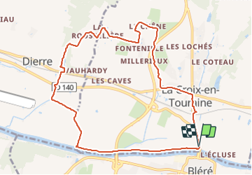
La-Croix-en-Touraine - 2016 08 28 - 10.3km - 2h15mn

Orcal37
User GUIDE

Length
10.3 km

Max alt
105 m

Uphill gradient
81 m
Km-Effort
11.4 km

Min alt
50 m

Downhill gradient
79 m
Boucle
Yes
Creation date :
2019-05-07 01:56:40.646
Updated on :
2021-08-24 16:28:33.135
2h15
Difficulty : Very easy

FREE GPS app for hiking
 SityTrail
IGN / Geographical institutes
SityTrail Plus
The world is yours!
About
Trail Walking of 10.3 km to be discovered at Centre-Loire Valley, Indre-et-Loire, La Croix-en-Touraine. This trail is proposed by Orcal37.
Description
La-Croix-en-Touraine - 2016 08 28 - 10.3km - 2h15mn
Photos

Positioning
Country:
France
Region :
Centre-Loire Valley
Department/Province :
Indre-et-Loire
Municipality :
La Croix-en-Touraine
Location:
Unknown
Start:(Dec)
Start:(UTM)
348251 ; 5244026 (31T) N.
Comments